The West Highland Way is the first official long-distance walking route in Scotland and by far the most famous. The trail was officially opened in 1980.
The West Highland Way is paved with interesting stories as you follow this historical route from Milngavie to Fort William, a distance of 153 kilometres/95 miles.
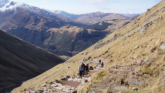
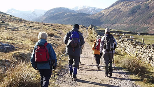
This walking trail takes you from the outskirts of Scotland’s largest city (Glasgow) and through the Scottish Highlands to Fort William along old drover roads on which highlanders herded their cattle and sheep to market in the lowlands. The trail continues on military roads that were constructed by troops to help control the Jacobite Clans and old coach roads and disused railway roads from more modern times. The West Highland Way is indeed a journey through some of the best scenery that Scotland has to offer.
Prices / Dates
Price: Low Season £1079 per person sharing
High Season £1189 Per Person Sharing
Single Supplement: +£650
Tour Dates:
Low Season: 1st April to 31st May & 1st
September to 10th October
High Season: 1st June to 31st August
Tour Grade: Moderate
Accommodation: Guesthouse, Hotel & B&B
Included / Excluded
- 9 nights bed & breakfast
- All accommodation is pre-booked in approved family-run guesthouses, B&Bs and hotels with all rooms en-suite.
- West Highland Way Maps and Rucksack Reader Guide Book.
- Luggage transfers daily while you walk with a small day pack.
- All information on trains or buses needed to get to your first accommodation in Milngavie and back at the end of the tour from Fort William.
- 24-7 Emergency Telephone support
- Public transport to the beginning of the tour and back at the end
- Packed Lunches
- Evening Meals
- Drinks and Snacks
- Personal Equipment
You have the option to arrive at Glasgow's main airport or Prestwick airport, which is only a short train ride outside of Glasgow. You will then catch a train to Milngavie to your first accommodation. We will supply you with all your travel detail to get to your accommodation.
Today's self-guided walk is a perfect introduction to the West Highland Way and the lowlands of the Scottish countryside. The walking trail follows a series of old railway lines and country tracks, offering you some superb scenery and your first glimpses of the Scottish Mountains. You may also get your first glimpses of some Roe Deer and birds of prey, including Kestrel and Red Kite. In Summer, this section of the West Highland Way also offers an abundance of wildflowers.
Distance: 19.5 km / 12 miles, Ascent: 200 m / 600 ft, Approximate walking time: 5 / 6 hours
Today’s walk is broken down into two parts, the first walk takes you through Garadhban Forest and across the side of Conic Hill, which overlooks the small village of Balmaha (a perfect place for a liquid lunch!) and your first glimpse of Scotland’s largest freshwater lake “Loch Lomond”. From Balmaha, the trail takes you along by the shores of Loch Lomond and into Ben Lomond National Memorial Park.
Distance: 22.5 km / 14 miles, Ascent: 345 m / 1035 ft, Approximate walking time: 6 / 7 hours
Almost all of today’s walking trail takes you along the eastern shores of Loch Lomond as the trail traverses through a mixture of woodlands under the steep slopes of Ben Lomond. This is probably one of the toughest days of the ten-day self-guided walk, but you will be truly rewarded with spectacular and stunning scenery across the loch and into the high distant mountains. If luck is on your side today, you may get a glimpse of the magnificent golden eagle. Since the early 20th century golden eagles in Scotland have recovered, having reached a low point of perhaps as few as 150 pairs. Now there are over 420 pairs and the population is stable.
Distance: 22.5 km / 14 miles, Ascent: 222 m / 666 ft, Approximate walking time: 6 / 7 hours
The walking trail now leaves Loch Lomond and takes you on a relatively easy section of the walking trail, north-west along by the base of Ben Glas Mountain, through Glen Folloch and on to Strath Fillan. As you travel along, you will cross and re-cross the river Folloch which is the main East-West natural divide of the Scottish Highlands. As you pass the village of Crianlarich, it is half-way on your day's walk but more importantly, it is halfway to Fort William! Before you get to your destination, you will pass what remains of the ruins of Saint Fillan’s Priory.
Distance: 20.5 km / 12 miles, Ascent: 200 m / 600 ft, Approximate walking time: 5 / 6 hours
“All travellers who use this wild and beautiful place will do so in peace if they tread their path lightly.” (An inscription from a plaque as you approach the remains of the priory)
Today's walk is along another easy section of the trail that takes you north out of Tyndrum on an old military road that was constructed around 1750. You will continue along by the West Highland Railway Line that links Glasgow with Fort William. The views along this section are mainly dominated by two mountains on the right, first Beinn Odhar and then Beinn Dorain. This section of the West Highland Way may be easy but it is incredibly beautiful and in summer it offers an array of wildflowers and green pastures.
Distance: 15 km / 9 miles, Ascent: 145 metres / 435 ft, Approximate walking time: 4 / 5 hours
Today's walk is along one of the most remote sections of the walking trail which follows an old drover’s road that skirts along the western fringe of Rannoch Moor. I can find no words that can justify my experience on this section of the trail. One has to personally walk it to experience the peace and serenity that it has to offer. Wild red deer, black grouse and sheep roam freely here.
Distance: 15 km / 9 miles, Ascent: 90 metres / 270 ft, Approximate walking time: 4 hours
From Kingshouse, the walking trail enters the beautiful scenery of Glencoe and at Altnafeadh the trail climbs steadily over the Devils Staircase. This is an old military road that rises to almost 500 metres/1500 feet at its highest point, before making a long descent into Kinlochleven. You will enjoy glorious mountain views throughout the day today.
Distance: 15 km / 9 miles, Ascent: 250 metres / 750 ft, Approximate walking time: 4 hours
The final section of the West Highland Way takes you back onto the old military road with a steady climb out of Kinlochleven through an area of natural woodlands that, every now and then, offers you some splendid views over Loch Leven and back over part of your previous walk. You will pass an old ruined village called Tigh-Na-Sleubhaich and clear evidence of its inhabitants can still be seen to the present day. The final part of the trail takes you down into Glen Nevis where you will have some great views of Ben Nevis, Scotland’s highest mountain. The walking trail finishes at the visitors' centre in Fort William.
Distance: 24 km / 15 miles, Ascent: 225 metres / 675 ft, Approximate walking time: 6 / 7 hours
After a hearty Scottish breakfast, you can take the train back to Glasgow.
We will supply you with all the travel information that you will need for your onward journey from Fort William.


