The Burren is on part of the Wild Atlantic Way. The name comes from the Irish word ‘boireann’ meaning “rocky place”.
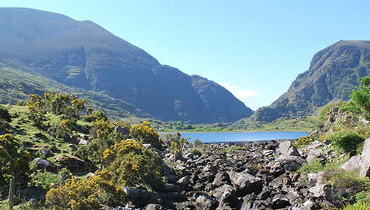
The Burren Way is a way-marked walking and hiking trail from Liscannor to Ballyvaughan. It passes by the famous Cliffs of Moher through a landscape dominated by Carboniferous limestone rock. This is a porous rock formed 330 million years ago from sediments of the sea and reshaped by glaciers from the last ice age. The action of water and ice over the years has resulted in the well-known bare fissured limestone pavements which represent the largest expanse of limestone paving in the world. As waterfalls on this rocky landscape, it does not drain easily but works its way down through the soluble rock to erode caves and form underground rivers and lakes.
The Burren caves are the most extensive in Ireland. Only a fraction have been explored, much more remain undiscovered. The Aillwee Caves were discovered in 1944 and provide a safer alternative to people wishing to experience caving in the Burren, without the dangers normally associated with this activity. Plantlife in the Burren is probably one of the most fascinating aspects of the landscape. There are arctic and alpine plants growing alongside Mediterranean orchids and maidenhair fern. Lichens such as Lugworth and Parmeliella thrive here. These species are the first to disappear in the presence of pollution and are a good indication that the air in the Burren is pure.
Mans most common mark on the landscape in these parts can be seen as Ringforts and Megalithic tombs. Later on, castles were the domain of the ruling class and this coastal trail is littered with examples of these at different levels of preservation or ruin. Some exist only as piles of stone, others as well preserved examples. The stone dominated landscape comes to a startling end at the Atlantic Ocean in the form of magnificent cliffs of stunning beauty. These cliffs provide special habitats for seabirds and plants that thrive in this environment. The most common birds at the Cliffs of Moher are Razorbill, Kittiwakes, Shag, Fulmar and Puffin.
While much of the Burren Way winds along quiet country roads, it does make use of green roads and old cattle drives that transect the limestone pavement.
Prices / Dates
Price: €749 per person sharing
Single Supplement: +€375
Solo Traveller Supplement: +€60
Tour Dates: 1 April to 15 October
Tour Grade: Easy
Accommodation: Guesthouse
Included / Excluded
- 6 nights bed & breakfast accommodation.
- All accommodation is pre-booked in approved and carefully selected family-run guesthouses with all rooms en-suite.
- Breakfast supplied each day
- Maps and all route notes.
- GPX Tracks
- Luggage transfers daily while you walk.
- All information on trains or buses needed to get to your first accommodation in Liscannor and back at the end of the tour from Ballyvaghan.
- 24-7 Emergency Telephone support
- Transfers from point of arrival to Liscannor or from Ballyvaughan at the end of the tour.
- Packed Lunches
- Evening Meals
- Drinks and Snacks
- Personal Equipment
You have the option to arrive at Dublin, Shannon or Cork airport and travel by bus or train to Liscannor to begin your walking vacation along the Burren Way. We will supply you with the necessary timetables and information to get you safely to your first accommodation.
Overnight Liscannor
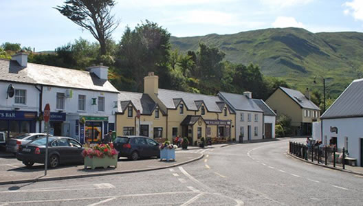
Liscannor is a popular angling and tourist village situated on the west coast of County Clare and your starting point for your walking holiday along the Burren Way. The area around Liscannor belonged in former times to the Chieftains of Corcomroe, the O’Connor’s.
From Liscannor the trail takes you along a country road that overlooks Liscannor Bay, through the farmland of Kilconnell to join a cliff path at Hags Head where the steep ground and breathtaking cliffs are home to numerous types of wildflowers and breeding seabirds. The walking trail leads you to the famous Cliff’s of Moher which reach up from the Atlantic Ocean to a height of 214m. Here you have the option to explore the fabulous new visitor's centre before continuing your journey to the village of Doolin, renowned worldwide as the traditional music capital of Ireland.
Distance: 19 km / 12 miles, Ascent: 820 m / 2460 ft, Approximate walking time: 5 / 6 hours
Overnight Doolin
Doolin's history is evident in the bare limestone landscape, Ringforts and kilometres of stone walls forming ancient field systems. Everyone who visits Doolin takes something memorable away with them, from having been part of inspiring music sessions to have found the peace to meditate on life’s challenges. You can explore the area around Doolin on foot or by bike (bikes are available for hire) or use the opportunity to visit Inihseer, the smallest of the three Aran Islands.
From Doolin, it is a short ferry journey from Doolin quay across to Iniseer (Inis Oir). Iniseer still holds onto Irish as its first language and the 300 residents still speak it as part of their everyday life. The island is an extension of the Burren in that it has been shaped by the same glacial processes as the mainland.
Overnight Doolin
Today’s route is a superb section of the walking trail that takes you through the hinterland of Ballynahown and onto the plateau of the Burren. You will traverse under Slieve Elva, the highest mountain in the area, and if you are feeling up to it, a short diversion will take you to the summit (344m).
Your descent takes you into the Caher Valley and down by the only over ground river in the Burren, the Caher River. Along the way, you will have fantastic views back to the Cliffs of Moher and across the Atlantic Ocean to the Aran Islands.
Distance: 22.5 km / 13.5 miles, Ascent: 852 m / 2556 ft, Approximate walking time: 6 / 7 hours
Overnight Fanore
Almost all of today’s walk takes you on old quiet country roads that loop around Black Head. You will enjoy some superb views over Galway Bay, the Aran Islands and across to the Connemara Mountains in County Galway.
Your day will finish in Ballyvaughan, a quiet fishing port on the southern shores of Galway Bay. The harbour village grew in response to the trade-in turf from Connemara, making it the capital of Clare in Victorian times. Ballyvaughan is rich in evidence of man's presence from prehistoric times through the famine era and is still a thriving village community today.
The walking route today takes you past Newtown Castle, which is a 16th century fortified tower house built for a branch of the O’Briens but passing into the possession of the powerful local O’Loghlen clan.
Distance: 20 km / 12 miles, Ascent: 755 m / 2265 ft, Approximate walking time: 4 / 5 hours
Overnight Ballyvaughan
Today’s route will take you on a circular trail starting and finishing in Ballyvaughan. The first section of the loop goes through a network of small fields with the distinctive stone walls of the Burren, and small areas of mainly Hazel trees, known in Irish folklore as ‘the tree of wisdom’. On your walk today, you will have a chance to visit the Burren farm shop and the Aillwee Caves. As you return to Ballyvaughan, you will travel along old green roads which are havens for the rare and beautiful flowers of the Burren.
Distance: 10 km / 6 miles, Ascent: 120 m / 360 ft, Approximate walking time: 3 / 4 hours
Overnight Ballyvaughan
Depart Ballyvaughan for home.