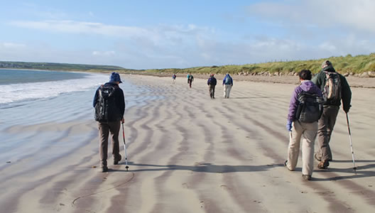
The Dingle Way is one of Ireland’s finest self-guided walking trails and is along part of the Wild Atlantic Way. Taking in a distance of 179 km/111.8 miles, the Dingle Way reveals to you some of the most startling scenery that you will find anywhere in Ireland. You will encounter an array of archaeological monuments dating back from the Mesolithic Period of around 6000 BC including Standing Stones, Ogham Stones and a multitude of beehive huts, evidence of the rich culture of a bygone age.
Hiking around the Dingle peninsula, you will enjoy views of lush green pastures sweeping down from the heather-clad mountains above to reach a wild and rugged Atlantic Coastline. The National Geographic Traveller has described The Dingle Peninsula as “the most beautiful place on earth”.
Prices / Dates
Price: €749 per person sharing
Single Supplement: +€375
Solo Traveller Supplement: +€75
Tour Dates: 1st April to 15th October
Tour Grade: Easy to Moderate
Accommodation: Guesthouse or B&B
Included / Excluded
- 6 nights bed & breakfast
- All accommodation is pre-booked in approved family-run guesthouses with all rooms en-suite.
- Dingle Way Guide Book
- GPX Tracks
- Details on restaurants and places of interest to visit along the way.
- Luggage transfers daily while you walk.
- All information on trains or buses needed to get to your first accommodation in Camp village and back at the end of the tour from Cloghane village.
- 24-7 Emergency Telephone support
- Packed Lunches
- Public transport to the beginning of the tour and back at the end
- Evening Meals
- Drinks and Snacks
- Personal Equipment
You have the option to arrive at Dublin or Shannon Airport and take a bus or train to Tralee, where you will take a 25-minute journey by public transport to the village of Camp. We will supply you with the necessary timetables and information to get you safely to your first accommodation.
This walk takes you across the hub of the Dingle Peninsula. Following a “Boirín” (a Gaelic word meaning small road), the walking trail leads you to a col between Corrin and Knockbrack Hills to reach a height of 235 m/705 ft. From here you will have some remarkable views of Baurtregaum Mountain, which is the highest mountain in the Slieve Mish range and an impressive megalithic fort that sits on the edge of Caherconree Mountain.
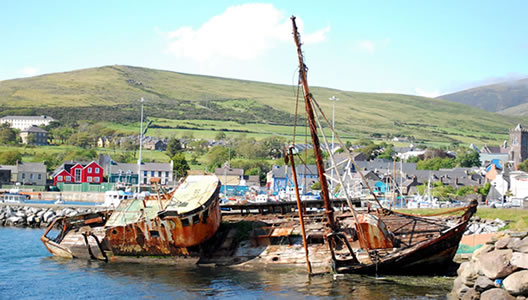
The trail then descends gently downwards and eventually offers you some spectacular views across the wildlife sanctuary of lnch Beach. It was here that some of the scenes from the famous “Ryan’s Daughter” movie were filmed.
Distance: 18.5 km / 12.6 miles, Ascent: 460 m / 1380 ft, Approximate walking time: 5 / 6 hours
From Annascaul the trail takes you west to the town of Dingle, along a series of minor roads that meander around the surrounding countryside and open mountains. You will have a chance to visit the magnificent ruin of the 16th century Minard Castle and stop off for lunch in the beautiful village of Lispole.
From Lispole the trail takes you north-west back towards the spine of the Dingle Peninsula. From here the views over Dingle Bay are simply awe-inspiring.
Distance: 22 km / 13.7 miles, Ascent: 568 m / 1704 ft, Approximate walking time: 6 / 7 hours
The trail from Dingle takes you further westwards through the village of Ventry and onto the golden sandy beach of Ventry Harbour. A country lane leads you on to the medieval roads of Slea Head. This area is dotted with a multitude of Clochans or more commonly known as beehive huts which date back to the Mesolithic Period of around 6000 BC. As your trail bends north around Slea Head, you will also have some stunning views back over the Great Blasket Island and your final view of Dingle Bay.
Distance: 25.3 km / 15.8 miles, Ascent: 683 m / 2050 ft, Approximate walking time: 7 / 8 hours
Once again, another superb section of the trail awaits you. Today's walk takes you north along the western foot of the peninsula by Ferriters Cove and the rugged sea-cliffs of the Three Sisters. From here the trail swings east to take you along by the sandy beaches of Smerwick Harbour. Your day finishes in the village of Feohanagh.
Distance: 22 km / 15 miles, Ascent: 429 m / 1287 ft, Approximate walking time: 5 / 6 hours
This is one of the most remote sections of the Dingle Way offering you a combination of history and breathtaking scenery.
The trail follows a green road that crosses the shoulder of one of Ireland’s highest mountains “Mount Brandon” standing at 952 m. You will continue past a standing stone that dates back over 3.500 years which still displays the symbols of Ogham Writing and continue over an area of blanket bog where turf is still harvested in the traditional ways of our forefathers. Your walking day will finish in the quiet village of Cloghane that lies in the shadow of Mount Brandon.
Distance: 28 km / 17.5 miles, Ascent: 750 m / 2250 ft, Approximate walking time: 8 / 9 hours
After breakfast, we will arrange transport for you back to Camp to get public transport to Tralee.